
Low and behold we had a day off and just the night before the brillant idea of hiking was placed in my head by Corinne. Sure, why not? I thought. So early today I set out on a trek to Columbine Lake. Like any good space cadet I researched directions the night before, so I headed towards Tabernash, taking county rd 83 which turns into 84 and continuing on 84 for 12 miles. This is your typical dirt, not well taken care of road that you are suppose to go 30 mph on, however you can't stay above 20 mph, because one of your tires may disappear into a hole. I drove past the reservoir and continued to the Junco Lake Trailhead, which actually has nothing to do with where I was going, but that is where I was told to begin.

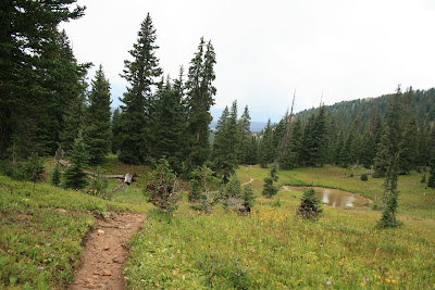
The trail was secluded and through the trees, and it rain alongside a creek. It was overcast for most of the trail and then the thunder started up, but luckily I was only hit by a few minutes of hail and then just clouds again. I soon came to a split in the trail, go left and climb to the divide, or choose right and head towards Columbine Lake.
Of course I decided to do the longer, more difficult, and steeper trail, Caribou Pass. Little did I know at this time, but I was headed to the Continental Divide. As I hiked I passed different bodies of water and different plants, but other than that I didn't see any animals or people.
So, this may have not been the best idea I ever had, but I decided to pursue wherever this trail led me. I ended up at the top of the mountain I saw when I left my car, but now there were too many choices to make.

Just over the cliff was two lakes and I was tempted to figure out where some trails led to, but since I was by myself I decided I should stay on some sort of trail. The only sign at the top of

the mountain was Caribou Pass which is where I just came from. I unfortunately didn't bring a map either, so I had three choices. One to go back the way I came, which was boring and I still had plenty of time to explore. Option two was to head to my left and option three, head to the right. Since I could see where option three led I decided to go for the mystery path that I still have no idea what it is called. I headed to my right.


Mind you at my car the temperature was a nice 60 degrees, as I progressed up the mountain the wind increased, there was still snow around, and it was about 40 degrees.
At this point I am realizing that my layers are great, however I needed to bring gloves, a beanie, and probably a face mask. Since I didn't have all that I decided to continue on, of course! Mind you, the path that I came from was developed and was maintained by use. This new path was another story.
First off it was on the side of a mountain, where one wrong move would send you down a mile rock slide, not very comfortable if you ask me. The other down side to this new trail was the rock piles blocking the path due to recent avalanches (I blame it on the "earthquake"). So continuing on this path was not only challenging, but also freezing. I had to take breaks from the wind and hide in the rocks, meanwhile trying to pull up some sort of map on my phone to tell me if it was worth continuing on or not. I couldn't pull up a detailed enough map, so I decided to trek along some more and see what would happen.
Low and behold just around the next turn was a beautiful lake.
I decided to explore around this lake for a while, until 5pm which is the time I set out to start heading back wherever I was so it would be mostly light on my decent. I have since found out that the trail I decided to take is called Fourth of July Trail and the beautiful lake that I found is Lake Dorothy. Fun facts about Dorothy, it is the highest lake in the Indian Peak Wilderness, it is about 100 feet deep, houses large trout, the majority of the water comes from Mountain Neva which is the backside of the lake (mind you there was still a significant amount of snow here), and the lake is at 12,061 feet.
Heading down the mountain presented itself with the same challenges as coming up. Avalanche residue covering the path, super cold wind, and of course my favorite hail! I occasionally looked at my compass to make sure I was at least headed in the direction I wanted to go. Then I thought about my initial purpose of this trip, to see Lake Columbine. So instead of meeting up with the trail, I decided to go straight down the mountain in the direction I thought it would be. Not one of my best ideas over. Each step included sliding a few more inches because it was too steep, in addition there was no way of actually telling where the ground was because I was walking through the forest. Plants up to my knees, creeks all over the place, plus blind stepping only to slide more. Well at least it kept things interesting. Eventually I ended up at Lake Columbine, it was everything that I was told that is was suppose to be.
Gorgeous and with Mount Neva behind it, it was amazing. After taking pictures and journaling a little, I decided it was time to head back to my car, also considering that I was freezing. I began the trek backwards on a trail that I have never seen. So, here goes another adventure. I pulled out my compass again and decided to head in a direction. After overcoming a few obstacles such as a 10 foot cliff that I was on top of and of course the unexpected creeks, I managed to head in the direction of my car. Shortly after I found a "trail."
Who knows who made this one, but it was terrible, it dead-ended, went through creeks, and there were way too many trees that feel on the so called "path." I came across a few small waterfalls and then finally came across a trail that looked real. I began taking this back, now remember I have never seen this trail or been on it before. Therefore I continued to check my compass to make sure I was at least headed in the correct direction. To add in another helpful factor, the sun went down.
So now I am on a trail that I have never seen in the dark. I am thankful it was a full moon tonight and I was able to walk with the moon behind me, and I could see my shadow that was
casted down through the trees. Eventually I made it to my car and began driving the 12 miles back to the highway. According to my calculations my trip was about 25,566 steps which is about 11.5 miles burning 981 kcal, gaining more than 2,000 feet and taking me just over 7 hours. All to say that is was completely worth it and I would do it again tomorrow, well maybe not tomorrow because I am going to be sore, but perhaps next week!

